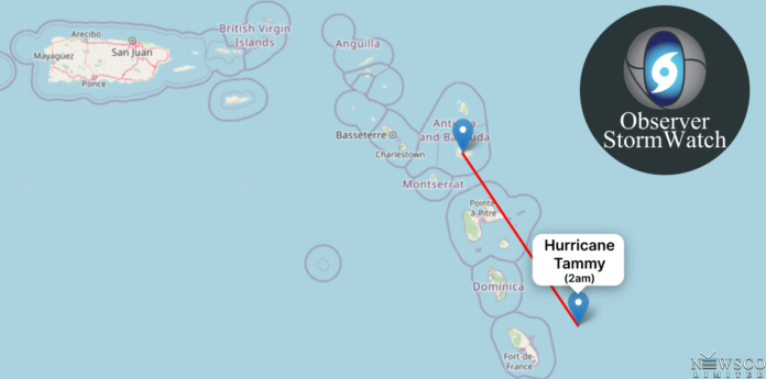
Saturday, October 21, 2023 – 2:00 AM AST
As Hurricane Tammy continues its relentless advance, the 2:00 AM AST update from the National Hurricane Center reveals that the storm’s centre is passing east-northeast of Martinique. As of this advisory, Tammy boasts maximum sustained winds of 80 mph, indicating a slight strengthening from the previous update. The hurricane is moving in a west-northwest direction at 9 mph and has a minimum central pressure of 991 mb.
Hurricane Tammy Advisory Number 11A
Location: 14.9N 60.3W
Distance: 180 miles southeast of Antigua, 15.59 miles closer than it was at 11 PM
Maximum Sustained Winds: 80 mph
Movement: West-northwest at 9 mph
Minimum Central Pressure: 991 mb
The areas under the hurricane warnings remain as follows:
- Guadeloupe
- Antigua, Barbuda, Montserrat, St. Kitts, Nevis, and Anguilla
- St. Maarten
- St. Martin and St. Barthelemy
A Hurricane Watch is still in effect for Dominica.
For Dominica, Saba, and St. Eustatius, a Tropical Storm Warning has been issued, indicating that tropical storm conditions are expected within these areas. Martinique remains under a Tropical Storm Watch.
The government of the Netherlands has taken the precautionary step of issuing a Hurricane Watch for Saba and St. Eustatius, while the government of Antigua and Barbuda has declared a Tropical Storm Watch for the British Virgin Islands.
A Hurricane Warning indicates that hurricane conditions are expected within the warning area in the next 24 hours, emphasizing the urgency for residents to complete preparations. Similarly, a Hurricane Watch forewarns of possible hurricane conditions within the watch area within the next 24 hours. A Tropical Storm Warning suggests that tropical storm conditions are anticipated within the warning area.
The projected path for Tammy indicates a shift toward the northwest during the morning hours, with subsequent north-northwestward and northward turns expected tonight through Sunday night. This trajectory forecasts that the centre of Hurricane Tammy will pass near or over segments of the Leeward Islands through tonight and then track north of the northern Leeward Islands on Sunday.
The intensification of Tammy’s winds is noteworthy, with the hurricane conditions expected to begin within the hurricane warning area later this morning, subsequently spreading northward across the Leeward Islands today and tonight. Tropical storm conditions are likewise expected within the tropical storm warning areas today and tonight, with the possibility of hurricane conditions in the hurricane watch areas during the same timeframe. Tropical storm conditions may occur in Martinique today and in the British Virgin Islands tonight and Sunday.
Rainfall predictions continue to be concerning:
- Leeward Islands: Forecasts suggest 4 to 8 inches of rainfall with maximum amounts of up to 12 inches.
- Portions of the Windward Islands: Expected to receive 2 to 4 inches of rainfall with maximum amounts of up to 6 inches.
- British and U.S. Virgin Islands into eastern Puerto Rico: Anticipate 1 to 2 inches of rainfall with maximum amounts of up to 4 inches.
These heavy rains could result in localized flash and urban flooding and potential mudslides in elevated areas.
Furthermore, the storm surge could elevate water levels by as much as 1 to 3 feet above normal tide levels in the vicinity of Tammy’s path across the Leeward Islands. This surge along the coast is accompanied by the presence of large and dangerous waves.
Life-threatening surf and rip current conditions remain a concern in the Lesser Antilles, driven by swells generated by Hurricane Tammy.
The next complete advisory is scheduled for 5:00 AM AST, providing the latest information on the storm’s trajectory and potential impacts. Residents are urged to stay vigilant, follow official guidance, and prepare for the approaching hurricane. Antigua and Barbuda, in particular, should remain on high alert.

